Street View
Street Viewreconstruction of a place
This workshop addresses the hypothesis that a large part of our knowledge of the world is based on media artifacts. Personal assessment, ideas and perceptions, most of what we supposedly know, is based on what we have seen through the eyes of others – on processed and mediatized audiovisual content.
The workshop was conducted with first semester students at the Zurich University of the Arts and can be supplemented with two additional exercises at its beginning and end.
Description
The participants analyze features of urban building as well as architectural and social characteristics of a place only defined by its coordinates. They do not yet know the place itself. The location is explored exclusively via Google Street View (GSV) and “photographed” with screenshots.
Based on this online research, the participants reconstruct the place in the form of a cardboard model. This model is staged with light and photographed from a perspective as close as possible to the one in the GSV screenshots.
Afterwards, the participants inspect the real places and compare the real life experience of their walk-through with their photos of GSV and the model.
The project also addresses the machine-generated imagery and modeling of GSV. GSV creates a photographic image without edges and without further composition, a technical, mainly machine-generated image construction that – perhaps for this very reason – suggests a high degree of authenticity.
By means of the construction of a model and the reality check in the real space on site, the differences between the image and the space constructions become evident.
Tasks and specific work steps
- Phase 1:
Participants work in groups of about 3–4 people and are given the coordinates of a place. They analyze the place via GSV regarding its architectural, social and urban building characteristics. (and its context within urban building). As an important rule, no other sources may be used. Afterwards they take a “photograph” (screenshot) of the place.
Duration: approximately 1 hour
- Phase 2:
Using only Google Street View image data researched online and from Google Maps (also indoor maps, depending on place and location), they reconstruct the site as a model in actual space, approximately on a scale of 1:35.
The material is cardboard, the surfaces are covered with prints of facade elements that were copied from GSV and then assembled in Photoshop.
Participants then stage the model to match the GSV screenshot as closely as possible and photograph it.
Duration approx. 1,5 days
- Phase 3:
The real places are visited and the situation on site is compared with the photos from GSV and the model. The real place is photographed in the best possible correspondence to the screenshot.
The three images (GSV, photograph of the model and photograph of the real place) are examined and compared in terms of their relation to reality.
Duration: approximately 1/2 hour per location
Two optional additional tasks:
- Entry task
Play an online game together where you land somewhere in the virtual world by chance and must find out where you are with the help of GSV. (Ex: geoguessr.com, virtualvacation.us, getlostgame.app). During the game, there is a discussion: On which sources are the individual assumptions based?
- Follow-up task (phase 4)
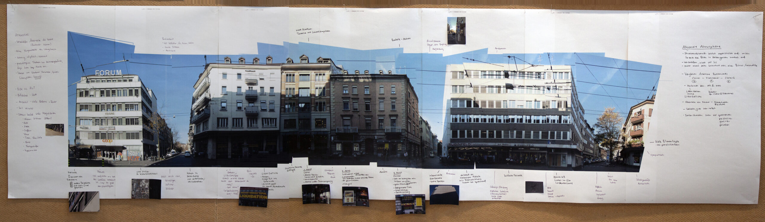
In a reverse process, so to say, the participants investigate a perimeter in the real world and seek a visual representation that is an alternative to GSV, that is a representation of the street closer to reality, and enhanced with comments from the research work: In groups, city blocks in the real space are documented photographically and the social space is researched in detail. The photos are assembled into panoramic images and additional notes and sketches of the observations made on site are collected. By repeating the project over several years, these panoramas become contemporary witnesses of urban development.
(Picture examples from Zurich Langstrasse).
Sources and References
- Jürgen Krusche: Strassenräume Berlin Shanghai Tokyo Zürich. Eine foto-ethnografische Untersuchung. Lars Müller Publishers; 1. Edition (2011)
- Klaus-Peter Busse: Den Atlas öffnen, in: Rudolf Preuss (Hg.): Mapping Brackel, Norderstedt 2008 (Dortmunder Schriften zur Kunst. Studien zur Kunstdidaktik Bd. 7), S. 15–22
- Helmuth Berking, Martina Löw (Hg.) Die Eigenlogik der Städte. Neue Wege für die Stadtforschung. Campus Verlag GmbH, Frankfurt/Main (2008)
- Andreas Kohli, Emilio Paroni (Hg.) An Accidental Tourist Guide – Exploring Hong Kong, Publisher Zurich University of the Arts, Zurich/Hong Kong 2017, PDF download:
https://medienarchiv.zhdk.ch/entries/accidental_tourist_guide_book
Images/Examples

Ergebnisse aus den Durchführungen der Aufgabenstellung © 2013-15 von Andreas Kohli und Emilio Paroni unter der Lizenz CC BY-NC-SA 4.0
Additional Information
Prior Knowledge and Preparation
Practical preparation for the teacher: definition of the given places
Material needed: cardboard, cutter, scissors, spray glue, b/w printer
Additional Tools
- Photoshop
- Google Street View